Florida flooding closes Broward schools after 15 inches of rain hits Hollywood
Broward County and Fort Lauderdale declared emergencies after an overnight deluge. Here's where more rain is due and how it could hit Thanksgiving travel.
What happened
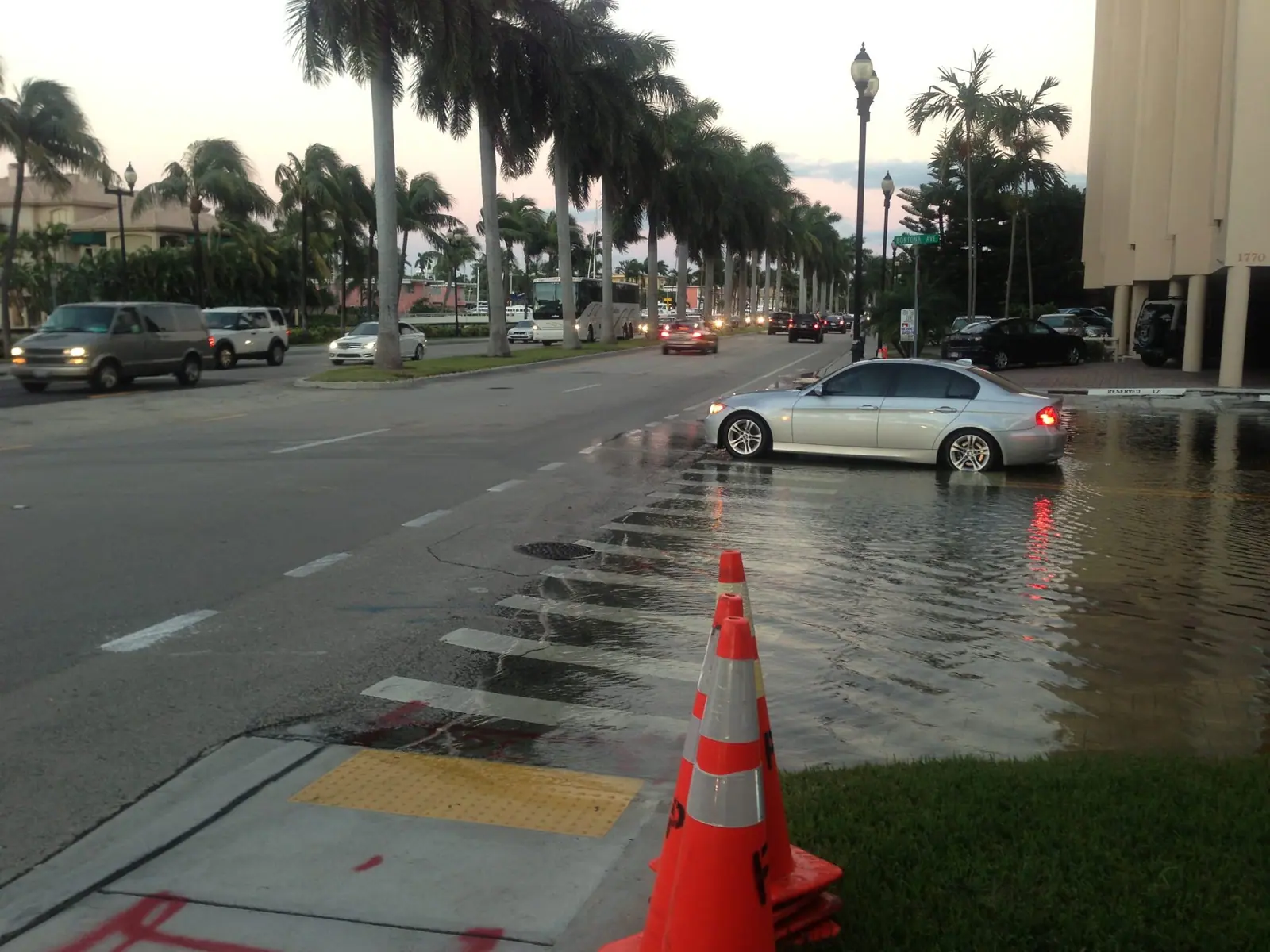
Florida flooding hit hardest in Broward County overnight Tuesday into Wednesday, Nov. 18, 2026, when the National Weather Service says up to 15 inches of rain fell around Hollywood. Roads flooded, parts of I-95 and Florida's Turnpike closed, and all Broward County public schools shut for the day. Broward County, Fort Lauderdale and Hollywood declared emergencies, and more heavy rain is forecast along Florida's east coast through Friday.
Key takeaways
- Hollywood police logged more than 300 calls for service between 11 p.m. and 4 a.m., and the roof of Temple Sinai in Hollywood collapsed. No one was hurt there, CNN reported.
- A temporary ground stop at Miami International and Fort Lauderdale-Hollywood International airports has been lifted, NBC 6 said.
- The same storm could move up the East Coast early next week, during one of the busiest pre-Thanksgiving travel stretches.
In this article
Most of Broward County went to bed Tuesday night under a flood watch. By morning, parts of Hollywood looked like a lake.
The National Weather Service in Miami says up to 15 inches of rain fell overnight, centered on Hollywood, the Miami Herald reported. Some neighborhoods got more than 5 inches in an hour. Cars stalled and sank on Sheridan Street west of I-95, water pushed under front doors, and tow trucks spent the morning pulling vehicles out of the deep spots.
And it isn't over. A slow-moving storm is parked off Florida's Atlantic coast, and forecasters expect more rain through Friday before it heads north, possibly right into the weekend before Thanksgiving.
Read also: Trump vows appeal after a judge blocks the closing of DC's East Potomac golf course · California high surf warning brings 30-foot waves, with more due midweek · A nor'easter could bring the Northeast its first snow of the season
How bad is the Florida flooding in Broward County?
It's the worst in and around Hollywood, between Fort Lauderdale and Miami. A preliminary look at 24-hour totals showed peaks of 12 to 15 inches across the hardest-hit parts of the county, USA Today reported, citing the Weather Service. CNN put it in perspective: that's more than three Novembers' worth of rain in a few hours.
Hollywood's mayor declared a state of emergency and told residents to shelter in place. Floodwater closed parts of Interstate 95 and Florida's Turnpike. Hollywood police took more than 300 calls for service between 11 p.m. and 4 a.m., and high-water vehicles were still out late Wednesday morning, according to CNN.
The rain also brought down the roof of Temple Sinai in Hollywood. Police said nobody was hurt.
Storms dropped hail up to an inch across, about the size of a quarter, along with the rain, NBC 6 South Florida said. Florida Power & Light showed about 1,900 customers without power as of 10 a.m., the Herald reported, and some residents also lost internet service.
Broward County schools closed, and emergencies declared
Broward County Public Schools first planned to open Wednesday. As the water kept rising, the district reversed course and closed every school and district office for the day, including before- and after-school care, extracurricular activities and district events. Students already picked up by buses were taken back to their pickup spots, the Herald said.
The district said it would post an update on Thursday's plans later Wednesday. Several Keiser University campuses also closed.
Broward County declared a local state of emergency, and so did Fort Lauderdale. A few cities are trying to help people save their cars:
- Fort Lauderdale is letting residents park free on the upper levels of a public garage, CNN said.
- Hollywood and Miami Beach are waiving fees at city-owned garages for residents, according to NBC 6.
- Davie closed its parks, trails and town facilities Wednesday and moved a council meeting and swearing-in ceremony to Dec. 2.
Air travel took a hit early on. A temporary ground stop at Miami International Airport and Fort Lauderdale-Hollywood International Airport has since been lifted. If you're flying out of either one this week, check your flight status before you leave home. Those are the same airports where we covered a taxiway crash last weekend in Two planes collide on a Miami taxiway, leaving two people hurt.
Was it a "rain bomb"?
You'll hear that phrase on local TV. Technically, it's the wrong label.
Alejandra Garcia, a meteorologist at the Weather Service office in Miami, told the Miami Herald that "rain bomb" is used loosely by broadcasters for any intense burst of rain. The real thing is a microburst, a narrow column of sinking air inside a thunderstorm that dumps its core of rain and hail all at once.
What actually soaked Broward is broader and slower. An area of low pressure that started over Texas drifted to Florida and got stuck there, held in place by strong offshore winds. That's why the rain kept coming back over the same neighborhoods.
Florida flooding this week: who's next
The worst of it is moving up the coast. Florida's east coast sits under a Level 3 of 4 flood risk on Wednesday, Thursday and Friday.
CNN's forecast calls for 3 to 6 inches across eastern Florida through Friday, with 8 to 12 inches or more possible in spots along the coast. Daytona Beach could see a foot, which would be about four Novembers' worth.
Brevard County is the big worry. Melbourne sits in the highest-risk zone Wednesday and Thursday, only a few weeks after it set a one-day rain record of 11.5 inches on Nov. 2. Rivers there are still running high. Melbourne is now about 8 inches short of its wettest year on record, a mark this storm could break.
By Friday, the flood risk stretches north to near the Georgia line, with rainfall rates above 2 inches an hour possible. Onshore winds and high surf will also bring dangerous rip currents and could cause major beach erosion along the coast.
Forecasters link the wet fall partly to a strengthening super El Niño, which tends to steer more storms across the Southeast.
Could this storm mess up Thanksgiving travel?
Possibly, and that's the part people outside Florida should watch.
The storm should sit off the Southeast coast until Saturday, Nov. 21, then start moving north. Forecast models show two main paths, CNN reported:
- Most likely right now: It tracks near or into the Southeast coast over the weekend and reaches the Northeast by Monday, bringing rain, wind and possibly coastal flooding. That would mean airport delays and messy driving on I-95.
- The milder option: It hugs the Southeast coast, then heads out to sea, sparing most of the Northeast.
The timing is bad. TSA screening data showed last year's weekend before Thanksgiving was one of the busiest stretches of the holiday week. AAA already expects a huge crowd on the roads and in airports; we broke down its numbers in AAA expects 81.5 million Thanksgiving travelers, ending a three-year record streak.
The National Hurricane Center gives the system a medium chance of becoming a tropical or hybrid storm if it stays over warm water long enough. If it does, it would be called Kyle. The name won't change much on the ground, though. Wind, heavy rain and coastal flooding are coming either way.
What to do if you're in the flood zone
A few practical points from local officials and forecasters:
- Don't drive into standing water. Wednesday's flooding left stalled cars all along roads like Sheridan Street, and it rose fast.
- Move your car to higher ground if your street floods often. The free and discounted city garages are there for that reason.
- Report utility problems to your provider, not 911, unless someone is in danger. Davie, for example, asked residents to call its utility line at 954-327-3750 for water main breaks or sewage overflows.
- Watch for school updates on the Broward County Public Schools website and its X account before Thursday morning.
We'll update this story when Broward schools announce Thursday's plans and when forecasters settle on the storm's path north.
Frequently asked questions
- Is there school tomorrow in Broward County?
- Not decided yet as of Wednesday afternoon. Broward County Public Schools closed every school and district office on Wednesday, Nov. 18, and said it would announce plans for Thursday, Nov. 19, later in the day. Check the district's website, its X account and local TV before heading out.
- How much rain did Hollywood, Florida, get?
- Up to about 15 inches overnight, according to the National Weather Service in Miami, with peak 24-hour totals of 12 to 15 inches across the hardest-hit parts of Broward County. Some spots got more than 5 inches in a single hour, CNN reported. That's more than three Novembers' worth of rain.
- When will the rain stop in South Florida?
- Not right away. The Weather Service told the Miami Herald there is no relief expected until Thursday or Friday, when the low-pressure system finally moves offshore. Florida's east coast stays under a Level 3 of 4 flood risk through Friday, with the biggest threat shifting north toward Melbourne and Daytona Beach.
- Will the Florida storm affect Thanksgiving travel?
- It could. Forecasters' most likely scenario has the storm tracking near the Southeast coast this weekend and into the Northeast by Monday, Nov. 23, bringing rain, wind and possible coastal flooding. That could slow airports and Interstate 95. A weaker track would send it out to sea instead.
Sources
- Intense flooding slams Florida from a developing storm that could snarl early Thanksgiving travel on the East Coast · CNN, Nov. 18, 2026
- Live updates: Broward declares state of emergency, schools close due to flooding · NBC 6 South Florida, Nov. 18, 2026
- Is South Florida experiencing a 'rain bomb?' Here's what to know · Miami Herald, Nov. 18, 2026
- Live weather updates: Broward floods from a 'rain bomb' · Miami Herald, Nov. 18, 2026
- Flooding closes schools in Florida's Broward County · USA Today, Nov. 18, 2026
- Broward County Public Schools, district offices closed Wednesday due to inclement weather · WSVN 7News, Nov. 18, 2026
Tags
- #Florida flooding
- #Broward County
- #Hollywood Florida
- #Fort Lauderdale
- #Broward County Public Schools
- #Thanksgiving travel
- #National Weather Service
About the author
Founder and editor
Marcia Reid is the founder and editor of TrendCanopy, where she reviews and edits every story.
Spotted an error? Read our corrections policy or contact us. Last reviewed November 18, 2026.
Related stories
Trump vows appeal after a judge blocks the closing of DC's East Potomac golf course
A federal judge ordered East Potomac Park and its golf links kept open through Nov. 28. What the order covers, Trump's redesign plan and what golfers face.
California high surf warning brings 30-foot waves, with more due midweek
A California high surf warning brought 25- to 35-foot waves and pier closures. Where it hit, when it ends and why another big swell may arrive Wednesday.

A nor'easter could bring the Northeast its first snow of the season
A nor'easter could bring the first snow of the season to interior New England, upstate New York and the Appalachians Thursday to Saturday. Timing and cities.
Multiple people are killed in a shooting in Moss Landing, California
Multiple people were killed and others hurt on Jetty Road in Moss Landing, Monterey County, California. What the sheriff has confirmed so far.

A Learjet crashes onto a road in Palm Beach County, killing all 9 aboard
A Bahamas-bound Learjet 60 crashed in Palm Beach County, killing all 9 aboard. What the FAA and NTSB say, what the pilot radioed and the impact on the ground.
Las Vegas flash flooding leaves 1 dead after Henderson water rescues
Las Vegas flash flooding on Oct. 30 led to three Henderson water rescues, one fatal. What happened, power and airport impacts, and the Halloween rain forecast.
Trending now
News ·
House Democrats pick Hakeem Jeffries for speaker, putting him in line to make historyTech ·
GTA 6 reviews give Rockstar a 99 on Metacritic, tying Zelda's all-time recordEntertainment ·
Kevin Feige says Marvel was swapping Kang for Doom before Jonathan Majors was firedMoney ·
Anthropic prices its IPO at $83 a share, valuing the Claude maker at $1.5 trillionNews ·
Xi greets Trump on the tarmac in China, a welcome Putin didn't get